Monday 24 September 2012

Hidden Gems at Carrigagulla

Carrigagulla 5 stone circle
It's our first real "stoning" day out for what seems like months. The forecast is OK, but after this Summer any forecast that doesn't mention continual rain would sound good !
We set off in good time. Sandwiches, chocolate and drinks all ready and sorted and we're heading off down our lane and out towards the main road.
Passing through Dunmanway, we get behind the now obligatory slowest driver on the road, occasionally overtaken by the also obligatory lunatic, who wants to overtake the whole line of cars.....blind bends and other cars coming towards us all the better !!
In Macroom, we are looking for the turning off to Ballinagree. Then up a pleasant road until we see the sign pointing left for our first destination - Carrigagulla Stone Circle.
We park up by the magnificent old farmhouse and have a chat with the Farmer who has just driven down the lane in his tractor. He lets us park there and gives directions to the circle, remarking that quite a few people get lost trying to find it !
It's about three quarters of a mile to a mile walk up an old boreen. The directions are to keep on the boreen up the hill and then down the other side to where a small plantation is growing up on the left. Then on the right will be a gate. The circle is in the bottom of this field. Sounds easy !
There are several stones in the fields to the left at the top of the hill, that look old. Some are being used as fence posts. I know that there is an old row up here and I'm going to have a better look on the way back.
The central stone, Carrigagulla Stone Circle
The recumbant stone, Carrigagulla
Heading further down the track, I pass a cross roads and then come to a ford. This doesn't seem right !
After a bit of backtracking, I spot the stones at the bottom of a rushy, marshy looking field. The gate into the field also leads down a narrow muddy boreen, which looks a better bet than trudging through the rushes and it leads down to an old abandoned, ruined farm. It's a magical place.
A step over the small stream which seperates the farm from the field, then its just a 50 yard hop and jump to more solid ground and Carrigagulla Circle - and what a wonderful circle it is. Even though though it's centre has been engulfed in reeds and rushes and the vegetation from the nearby hedgerow is encroaching, it is still in great condition. I count 15 stones still standing - including the low recumbant and the 2 radially set portal stones. A couple of stones have fallen and near the centre lies another. It is aligned just off NE-SW at 245 degrees,which according to Jack Roberts, is for the Cross Quarter.
I take several photo's and admire the extensive views. Carrigagulla NE circle is only about 500 yards away to the North, but impossible to see, because of the forestry.
The Portal stones at Carrigagulla stone circle
Carrigagulla Stone Circle
Back through the farm and down to the boreen, where I notice a small post pointing into the field of the stones. I don't know how I missed it on the way ! though in my own defence - it is hidden in the undergrowth !!
The ruined farm at Carrigagulla
Ruined farm at Carrigagulla
The ruined farm at Carrigagulla
Spot the sign!
Further on up the boreen and I'm arriving at the standing stones. There is one obvious standing stone (alongside a fallen stone) in the middle of the field on the right. I think that the two gate/fence posts were part of the row, before ending up in their present positions.
remains of Stone row at Carrigagulla
remains of the stone row at Carrigagulla
Back to the car and off to our next stop - just a few hundred yards further on up the road is a turning into the Coilte forestry plantation. We follow the track until we come to an obvious right hand turn leading to a dead end.
I know that Carrigagulla NE is just down this track and off in the trees somewhere. I have explicit directions (picked up from The Modern Antiquarian site). Seems straightforward. Walk to end of track - go west 120 paces - then North 45 paces into trees and voila !
I get to the end of the track,and then step into what looks like an innocuous little puddle....... seconds later I am knee deep in black, smelly bog water, which is rapidly filling my boots. Not quite what I had in mind, as I pull myself up onto drier land. I now forget my Wests from my Norths and somehow circle back to the car.
Not giving up - its back down the track and then find an obvious dry and easy step over and this time head straight into the trees (right at the corner) and head West. After 100 yards or so I can make out some stones over in a clearing to the right.... and here it is,another magical sight beholds me. Carrigagulla NE five stone circle !  If this circle was just sitting in a field, it would be quite plain. But here in this clearing amongst the conifers it is special -  "a must visit" circle.
Again aligned for the cross quarter (240 degrees - Jack Roberts). All five stones are upright and in good condition.
5 stone circle at Carrigagulla
5 Stone Circle at Carrigagulla
The 5 stone circle at Carrigagulla
I head back out to the track and squelch my way back to the car. After ringing out my socks, we have our packed lunch whilst sitting listening to the birds singing.
Looking at the map, we should have spotted a stone row on the way in and have to wonder how we missed it, it being only yards from the track. It is just so obvious on the return !
Three stones make up the row. One large stone and one very small stone are still standing and another large stone lies fallen. The area has been clearfelled and the row is now fenced off. The fallen stone was damaged in an attempt to protect it when the trees were felled. The machine moving it accidentally dropped it, causing a section to shear off ( http://www.excavations.ie/Pages/Details.php?Year=2003&County=Cork&id=9521 ).
Stone Row at Carrigagulla
Next off - we head back out to the main road, taking a right at the bridge and following the lane. We spot Oughtihery five stone Circle in the fields to the left.
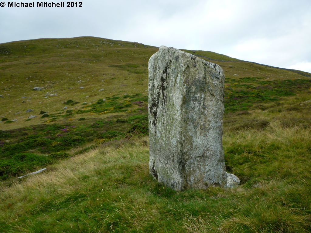
There's a farm just along a little... and a large stone set near the entrance lane. Not too sure on this one's antiquity, but it looks impressive standing proud as it does at the roadside.
Luckily the Farmer and his wife are just driving out and I ask them for permission to go over to the circle. Permission granted, though he warns us that the fences are all live !
Roadside Stone
Back to the nearest gateway and trying to work out the easiest way through the absolute myriad of electric fences across the fields. Luckily most are just high enough to be able to roll underneath and eventually the circle is reached.
This one is looking a little neglected. The interior has been used as a dump for all the field clearance stones, which is a shame as the circle itself is in good condition. In the same field, lies the scant remains of a wedge tomb. Several  more electric fences over is the massive 10-12 foot tall Maulmore Standing stone. In fact part of a stone pair - the second being not much more than a mere stump hidden in the long grass.
Oughtihery Stone Circle
Scant remains of the wedge tomb at Oughtihery
Maulmore Stone
Maulmore Stone

Time is getting on now so we head back to the car and carry on down the lane. There's a sign for a "Ring Forte" and Cross Slab, so we have a quick look. Up some steps and into a clearing, This is obviously the ring fort but it is too overgrown to make much sense of and there is no sign of any cross slab !
Can't win them all....... Homeward bound we head, happy. It's been a good day and we've had our stone fix.... until the next time !

Tuesday 17 April 2012

The High Carneddau

Carnedd Dayfdd from Carnedd Llewellyn

This is another of my walks in the Carneddau, from July 27th 2011.

Another gloriously hot and sunny day, with just a light Northerly breeze.
I get the early train fro Llandudno to Llandudno Junction, where I change and hop onto the Blaenau Ffestiniog train.
I'm only going as far as Bettws Y Coed, where I'm catching a Snowdon Sherpa bus to Capel Curig. Luckily it all runs smoothly and I am soon being dropped off where the road turns onto the A4086 at around 9 O'Clock..
There's a little bit of road walking to start until I pass Bron Heulog and head off up the footpath and strike out over the moorland towards Llyn Cowlyd. It's fairly easy going.Birdsong fills the air, Meadow Pipits, Skylarks,Wrens and a Whitethroat all joining in.
The trackway brings me to a man made leat, which I cross and then follow  round as it skirts the bottom of Pen Llithrig Y Wrach (The Slippery Slope of the Witch), across Cwm Tal Y Braich. A family group of 3 Kestrels are hunting in the Cwm and smaller birds are popping up everywhere. Stonechats, Whinchats, Grey Wagtails and Wheatears, a mixture of adults and juveniles.
Llyn Cowlyd

Tryfan and the Ogwen Valley
The leat turns in a South Westerly direction and I follow until it reaches the Southern end of Y Braich. This is the start of my climb up to Pen Yr Helgi Du.
It's steepish but steady going and seems to take ages before I at last see the summit cairn. A ring tail Hen Harrier is quartering the hillside nearby. At 2733 ft this is the smallest of todays hills, but the views from up here are amazing and it's an ideal spot to sit, have a drink and a sandwich and look out over Snowdonia. The distinctive shape of Tryfan and Y Garn on the opposite side of the Ogwen Valley. To the North is the lush valley of Cwm Eigiau  and to the West I can see my next objectives - Carnedd Llewellyn and Carnedd Dafydd.
Summit Cairn, Pen Yr Helgi Du

Bwlch Eryl Farchog

Bwlch Eryl Farchog
Before that though, there's the little matter of Bwlch Yr Eryl Farchog. The ridge that runs between Pen Yr Helgi Du and Carnedd Llewellyn. I retrace my steps a little and join a path of sorts that links up with the ridge. It saves going down the rather steep bit from the summit. It's a narrow ridge but not too narrow. There's a fair old drop either side but nothing too worrying. A bit of scrambling at the end of the ridge by Craig Yr Isfa and then Its the start of the slog up to the summit of Carnedd Llewellyn. A well worn track zig zags its way upwards to the top. After a couple of stops to take in the views and take breath, I'm there at the second highest point in Wales - 1064m/3491 ft. I don't linger for long, because I know that I'll be back here again after my detour over to Carnedd Dafydd and back. I didn't want to get all the way up here and not bag Dafydd as well.
Ffynon Llugwy from Bwlch Eryl Farchog

Looking back to Pen Yr Helgi Du from Craig Yr Isfa

Cwm Eigiau from Craig Yr Isfa
So I head down to Bwlch Cyfryw Drum and across Cefn Ysgolion Duon and up to the Summit Cairn of Carnedd Dafydd at 1044m/3425ft the third highest in Wales. The clouds are rolling in now and Llewellyn has completely disappeared. But it's not long before the blue skies return once more.
I retrace my steps. Ravens call from the steep cliffs of Ysgolion Duon and there's a familiar call of a Chough as I pass back over Bwlch Cyfryw Drum.
Bwlch Cyfryw Drum from Carnedd Llewellyn

Low cloud rolling over Carnedd Llewellyn

Carnedd Dafydd

Soldiers heading into the mist towards Pen Yr Ole Wen
There are a few people up on Carnedd Llewellyn, though not half as many as I thought that there would be. I cross over the summit and through the boulder field, North Eastwards to Foel Grach (976 m/3202 ft) my third 3000 footer of the day.There's a fair size cairn on the summit here.
Foel Grach

Bwlch Eryl Farchog from Foel Grach
Next its West over the grass moorland to join the footpath which is marked on the OS map but not recognisable on the ground. I head towards the Northern foot of Pen Yr Helgi Du to join Afon Eigiau. There are old work buildings and spoil tips showing that this was quite an industrious place in its day.I find a proper track which leads me through Cwm Eigiau, past the ruined farmhouse of Cedryn. After a while, I leave the track and follow the footpath up over the hill, past another ruined farmhouse (Eilio), over another hill, down the other side... under the massive water pipe which comes from Llyn Cowlyd and out on to a tarmaced lane near Siglen. It's a bit of a hard slog from here. My legs are tiring and the road seems to go on forever, before dropping steeply down into the village of Trefriw, where I get a cold can of Pepsi and an Ice Cream. From Trefriw there's a long lane to the river, where a footbridge crosses Afon Conwy. A few more yards and I am at the station for a welcome sit down to wait for the train. Ten and a half hours of hill walking, over 20 miles and taking in three more of the 3000 footers and some great countryside. All in all another terrific day in the mountains.  

Old Quarry Workings in Cwm Eigiau

Quarry Buildings in Cwm Eigiau

Eilio

Bridge over the Conwy at Trefriw

The quiet side of the Carneddau

The Great Orme from Conwy Mountain
I've been thinking a lot about the mountains of Snowdonia recently and thought that I would put a few posts up of a few of my walks there before we moved to Ireland.
First up is a trek across the lesser known hills in the Carneddau.

20th July 2011
I set off from Llandudno Junction and walk across the Conwy Estuary and past the Castle into Conwy.
Conwy is a lovely old walled town, dominated by the Castle. I'm following the A547 for a little way before turning off and over the railway bridge into Cadnant Park, then down a narrow lane and joining the North Wales Path through the woods and up to Conwy Mountain (Mynydd Y Dref). At it's highest point it's only 244 metres (800 ft) but it has commanding views over the Great Orme and Conwy Bay.
As I go along the ridge I pass Castell Caer Sion, an Iron age hillfort. The path starts to lead down and round eventually coming out onto a minor road (the Sychnant Pass). I cross the road and go through the gate into the Pensychnant nature reserve and still following the North Wales Path make my way up to the Eastern Carneddau. Passing Maen Esgob on my left. As I go over the stile I am lucky to see two Peregrine Falcolns fly over from Fairy Glen. Turning left and leaving the North Wales Path. Llyn Y Wrach (the lake of the Witch) has dried up completely ! On reaching the dry stone wall I turn right and follow the wall along. After about a quarter of a mile I come to Hafodty Stone Circle. It's not in the best of states.... only three stones remain upright. Several more lay flat or half buried ! There is a standing stone (Maen Hir) several fields to the South (more easily seen by following the wall until you are due West of it).
Hafodty Stone Circle

Maen Penddu
Carrying on along the path in a Southerly direction then veering off a little South West around some enlosures and I come across the big bulk of Maen Penddu Standing Stone,which stands about 6ft tall and 3 1/2 ft wide. The farmer comes by on his quad bike and stops for a chat before heading off for his lunch.
The next stop is going to be Caer Bach. Another fort, possibly post Roman rather than Iron age.
Then following the wall South West, I stop and have a long chat with another Farmer doing some stone wall repairs. Time's getting on a bit and I've got a long way to go still but I miss the footath which shoots off across the fields, so I carry on to Cae Coch farm.
Cae Coch Standing Stone

Maen Y Bardd

Maen Y Bardd
There's an old Roman road which runs up from Caerhun and crosses through the mountain gap down to Aber then on to Caernarfon (Segontium). Well I'm detouring down towards Rhiw to see the Standing Stones of Cae Coch and Ffon Y Cawr and the Dolmen of Maen Y Bardd (Stone of the Bard).
Retracing my steps back up to Cae Coch Farm, I follow the tarmaced road (which runs parallel to the Roman road), looking out for the small stone circle of Cerrig Pryfaid on the left. It's not easy to spot, all the stones are low and the grass is tall ! A step stile gives accessover the wall and I seethat there are a couple of outliers assosiated with the circle here as well.
The tarmaced road comes to an end a few hundred yards further on and there is a small car park which would be ideal for anyone just wanting to visit the Tal Y Fan area and it's richness of stones.
The road now rejoins the Roman road which is now just a track. Coming to the top of the pass, here are the two Standing Stones which give the pass it's name Bwlch Y Ddeufaen "Pass of the two stones". Two substantial stones in a great setting, only marred by the line of electricity pylons which runs up the valley.
Cerrig Pryfaid Stone Circle

Bwlch Y Ddeufaen Standing Stones

Bwlch Y Ddeufaen Standing Stone
Just beyond the stones, the track passes through a gate and this is where I leave the Roman road and head up hill towards the first big hills of the day. The going gets steeper as I pass the cairn of Carnedd Y Ddelw and South up to Drum (2526ft). There are great views of Llyn Anafon overlooked by Llwytmor and Foel Fras. There is a cairn here marking the summit- Carnedd Penyborth Goch, which has been turned into a shelter from the wind.
Carnedd Penyborth Goch
From Drum, I climb higher, the ground is a little boggier being the watershed for the numerous streams that feed down into Llyn Anafon.
The low cloud descends as I approach Foel Fras, which at 3091ft (942m) is one of the Welsh 3000's and the highest point of my days walk. It's a vast stony plateau, the summit marked by a trig point. Luckily the misty low cloud evaporates and the extensive views open up once more. I hear the familiar call of a Chough and sure enough a group of four birds fly up from just over the wall.
Foel Fras

Garnedd Uchaf
Moving on, it's a fairly easy stroll over to Garnedd Uchaf (3038ft), now renamed Carnedd Gwenllian after the daughter of Llewellyn. It's another of the Welsh 3000's. There are lovely views over to Carnedd Llewellyn, Carnedd Dafydd and Yr Elen. All the hills in this part of the Carneddau have extensive boulder fields around the summit and Carnedd Uchaf is no exception.
It's all downhill from here. Passing Yr Arig and onto Bera Bach (2648ft) then Drosgl (2487ft). A slight detour up Gyrn Wigiau (2110ft), then down and around Moel Wnion.
The great waterfall of Rhaeadr Fawr (Aber Falls) comes into view, gushing down off of the mountains. I can hear it from up here !
Bera Mawr, Bera Bach & Drosgl

Bera Bach
My path takes me round Moel Wnion, over Cras, passing a cairn on the way and down to rejoin the North Wales Path, this time in an Easterly direction. Three more Choughs are feeding down amongst the Sheep.
Once again I leave the North Wales Path and head down the steep footpath which leads to Aber village. It's a killer on the knees. I always think that going down is way worse than going up !
Down in the village, I make my way to the bus stop and sit and wait for the bus to take me back to Llandudno.
It's been a long (11 and a half hours and about 23 miles),but pleasant walk in the quieter half of the Carneddau. Other than the two Farmers and a couple of people on Conwy Mountain I've not seen a soul. My legs are aching but I'm feeling good !
View of the higher Carneddau fro Bera Bach

Cairn on Cras