Sunday, 11 March 2012

A complex complex at Mill Little and yesterdays burial found !

Mill Little
10th March 2012

Today we're going to have another look for the elusive boulder burial at Coolcoulaghta. Looking at the map when we got home yesterday, it looks so obvious at the side of the road. A quick check on the national monument survey web site to check that it is actually still there.... it is !
So, today, we are going to approach from the opposite direction and see how that goes.
So we head for Durrus along the Glenlough Road from the N71 and try to work out where the left turning that we need is. Hmmmm we think that this is the one, as we head downhill and round the sharp bend which takes us back steeply uphill. It's all looking familiar now and it should be somewhere around the next bend and along.... there it is ! It's so obvious coming in this direction.
There's a handy little pull in. I won't need my boots for this one, it's only just up the track !
Through the gate, up the track and there it is before me. A wire fence had enclosed it but is now half pulled down. I step a bit nearer and my foot disappears about a foot down into the black peaty boggy goo. Maybe I should of put my boots on after all ! There's a nice squelching noise as  I extract my foot, luckily my shoe is still attached to my foot !
The boulder burial itself sits in the corner of the "boggy" field, looking out over Dunmanus Bay, with Mount Corrin to the South West. There are two visible support stones . Photo's taken and scenery admired, I head back to the car.
Coolcoulaghta Boulder Burial

Coolcoulaghta Boulder Burial
We have got to call into Bantry next....and  I've now got a distinctive sort of peat bog aroma about me. Hopefully no one will notice !
After a successful stop in Bantry, we are now supplied with lemon and choc chip cakes and we're off up the road to Mill Little.
Turning off at Ballylickey and following the road as if going to the Coomhoola Valley, go left, following the signs for Priests Leap instead of going over the (second) bridge. After a while, as you come into Mill Big, there's a left hand turn. Follow this road, over a bridge then right and over another bridge. There's a small layby on the left (with a big pile of chippings). Go through the two gates and head down the field, you can't miss it !
Stone Pair at Mill Little
Five Stone Circle at Mill Little
 The Mountains of Cobduff (An Cabh Dubh) look down on a confusing mix of stones.. the complex complex that is Mill Little !
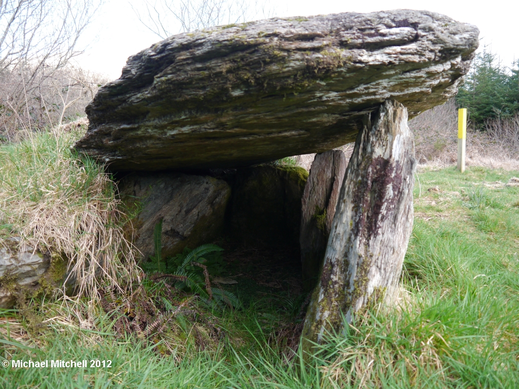
The obvious feature as you walk down the field, is the row of three boulder burials. The third supported by three stones, like a little Dolmen.
The first stones that you come across however, are a stone pair. Aligned NNE-SSW. The SSW stone is 1.2 metres high, whilst the NNE stone is just 0.75 metres. Other stones lay scattered beside. Next comes the line of boulder burials. The support stones of the first next to the large boulder. The second has no support stones and just rests on the surface. The third, as already mentioned, looks untouched and is a great example of a boulder burial.
Mill Little

Mill Little

Mill Little
Finally, there is a five stone circle. Three uprights remain, with a fallen slab and a broken stump. The portals seem to have been set end on, thus forming an entrance.
Some people think that there was originally a large multi stone circle here, which was destroyed and replaced later by the five stone circle. Indeed, there is a pile of large stones by the field hedge beside the river.
Breeny More comes to mind for comparisons. The truth, will probably never be fully known, but it is a fascinating and enigmatic place nonetheless.
Back to the car for a piece of cake, before heading back home, already thinking about where to go tomorrow.
Mill Little

Mill Little

Rathruane More Boulder Burial

Dunmanus Bay
9th March 2012

Just a quick visit today. We had to go to Ballydehob, so thought that we'd pop along to the boulder burial a few miles up the road at Rathruane More and possibly a few more sites further up that way.
The boulder burial is easy to find, in a field, just off the road on the Ballydehob to Durrus road.
You can park in the gateway opposite. As there were no animals in the field today, I hopped over the gate and under the electric fence. Grid ref is V964364
Rathruane More Boulder Burial

Rathruane More Boulder Burial
The boulder is a fair old size, and sits on four support stones. There is a cup mark on the surface. There are views over to Mount Gabriel, which is sitting in the mist today.
Rathruane Boulder Burial

Rathruane Boulder Burial
Getting back to the car, we have an audience. Sheep of all sorts and sizes stand at the gate by the car thinking that we have come to feed them. They seem a little disappointed when all I do is take their photo !
Next, there is supposed to be a standing stone in a field to the right, up the next right turning. We don't have any luck with this one. The field hedge is quite high and  the field is overgrown. Oh well, we give up on this one and instead just drive round the lanes, seeing if we can spot anything interesting. I do know that there is another boulder burial around, on the North West side of Mount Corrin. It should be right next to the road according to the OS map (which incidentally, I have left at home !).
No luck again. One out of three today - you can't win every time... Lovely views over Dunmanus bay to compensate though !
Feed Me !!!

Monday, 5 March 2012

Barraboy... Mountains and Wedge Tombs

Looking towards the Caha Mountains
5th March 2012

The Weather forecast is actually right today, the Sun is shining away in a bright blue sky. There's a slight frost... perfect Hill Walking weather.
Off out by 7:30 this morning and on my way to the Caha Pass, rom where I am going to head across to Barraboy.
It's half past eight by the time I get through the umpteen stop/go boards and to the first tunnel to park in the small layby next to the "Welcome to Cork" sign. Boots on and start the climb up to Turners Rock. The views are simply stunning, I could never tire of looking at mountains and water. The snow capped Magillycuddys Reeks are shining in the sunshine, Carrantuohill appearing then disappearing in the low clouds hanging over Kerry's finest.
Snow Capped Reeks
Turners Rock
I cross the fence from the Cork side to the Kerry side and follow the Beara Way loop yellow posts and the wire fence  Eastwards across the hilltops. Meadow Pipits parachute down in song flight and an occasional Skylark bursts into song. Apart from that, it's just me and the mountains !
Barraboy is still quite a way off as I pass over Esk Mountain. It's certainly wet up here, wet and slippery, as I slosh my way along.
The Way Ahead
The radio mast at the top of the old track from Canrooska to the Esk Valley comes into sight, and I descend slightly, to cross the track.
This is where I leave the Beara Way and continue uphill, pulling myself on the wire fence, up the steep and very slippery peaty slope. Soon the ground starts to even out, and I see the cairn at the top of Barraboy about three quarters of a mile ahead. I cross the fence back to the Cork side, as the going looks easier. The wide expanse of blanket bog to the South comes into view and I can just about make out the two Wedge Tombs right in the middle !
Barraboy
 Two Ravens circle overhead, as I arrive at the summit of Barraboy. 480 metres, 1574 feet above sea level. The modern cairn welcomes me to the top. It sits in the centre of a ruined circular cairn. Barraboy in Irish, is Cnoc Bharr Bui, which means "the yellow top" and you can see why - the long golden grass adorns the hillsides.
Blanket Bog and Wedge Tombs
 A quick drink, before heading South and down to the blanket bog. It's fairly steep but the going isn't too bad. There are plenty of sheep trails to follow. This is the watershed for the Canrooska River. Three small streams spring up out of the peaty ooze and merge ito one. Thankfully, crossing them presents no difficulty and I am now just yards away from the first of the two wedge tombs. The two are 20 metres apart on a North - South allignment.
Northern Wedge Tomb

Northern Wedge Tomb

Northern Wedge Tomb
 This first one is the smaller of the two. A single capstone sits atop of three uprights and two fallen stones. A further stone sticks out of the peat at the South Eastern front. This wedge tomb is aligned NNW-SSE.
The second one is more substantial.and has an interesting internal slab, which has had a notch cut into it, which must of had a special function. Maybe to let the Sun shine through at a certain time ?  It's not easy to work out exactly whats what on this one, as the peat and heather have started to take over.Neither bears any resemblance to the descriptions given on the National Monument website !
Southern Wedge Tomb

Southern Wedge Tomb

Southern wedge Tomb

The Notch in the Southern Wedge Tomb
 My next objective is the large standing stone at Crossterry East, some three quarters of a mile to the South West. I've got several streams to cross and several gullies to work my way  through. The stone is visible from the wedge tombs but disappears from sight as I walk Westwards, so a lot of this is going to be guess and hope ! A small Common Lizard, sits motionless sunbathing in the grass as I pass by, posing nicely for his photograph
Lizard
 I must have gone through four or five gullies now, there's a real eerie feeling, wandering around amongst the massive boulders.
There's a sort of line of small trees heading up the hill, and that is what I am aiming for. Jumping over a large rock, I nearly land on a dead Sheep... lovely !!
 A small stream trickles down beside me as I pass between the flat hillside slabs, heading ever upwards, and eventually coming to another barbed wire fence. A quick scan around and the stone is actually still a way off, but all I have to do is follow the fence down to it.
Crossterry East Standing Stone is in a small wire enclosure. It's a fair size - 2.3 metres high, 1.15 metres wide and 0.85 metres in depth.It looks out over Bantry Bay and to Barraboy in the North East. To the West are the hills of the Beara Peninsula.
Crossterry East Standing Stone

Crossterry Standing Stone
 There should be another megalithic tomb, somewhere to the West of here, just before the track, but search as I might, I cannot for the life of me find it. Maybe it has been churned up to make way for the forestry that's springing up here !!
I'm now out on the Beara Way track, which will take me back up to the radio mast. It's a steep haul up but I'm soon there. Over the stile and make my way back up Esk Mountain, having a quick look back over at Barraboy and Canrooska to see where I have been.
The Track
 I notice the Paps of Anu away in the far distance. Didn't notice them earlier.
Back at Turners Rock, I cross back to the Cork side and make my way back down to the car.
It's been a really lovely walk, about 8 or so miles I reckon, perfect conditions and it's been great to get back out into the hills. I've not seen a single other person all day !!!
Looking forward to getting home and having a cup of tea !
At home, I'm rather disappointed to learn that I missed a standing stone some 200 metres from the wedge tombs !
The Paps of Anu in the distance

Drombeg

Drombeg
4th March 2012

Just a quickie today. We popped in on Drombeg Circle, as we were passing. It's probably the most visited megalithic site in West Cork. Indeed, it was our first Irish Circle and we've been back a few times, including for the Winter Solstice.
It's easy to find, turn off the N71 at Leap and head for Glandore. Go straight through the village and follow the road until you see the (brown) sign directing you right. Follow this road as it twists and turns and you will see a small car park on your right. Yes .. there's even a car park for this one ! There's a track at the far end of the car park, leading you down to the stones.
I'll keep the writing brief and just post some photo's
Drombeg

Drombeg

Drombeg

Saturday, 3 March 2012

Breeny More and The Mealagh Valley

Inchireagh Stone Circle
Breeny More and The Mealagh Valley

March 1st 2012
Well it's St Davids Day today, the sun is shining and the sky is blue. Looks like a good day to hit the backroads of West Cork to see what we can find !
I've been wanting to get to Breeny More Stone Circle for a while now, so that will be a good place to start. It's easy to get to. From Bantry direction, head out on the N71 to Ballylicky, then take the R584 to Kealkil.Take the right turn by the garage/shop then turn right by Browns Bar and follow the signs for Kealkil Circle up the steep hill. Just past the sharp right bend where Kealkil circle is, you'll see a track on your right. Well I say, a track. But when you get there it looks like a pull in where the farmer dumps all his unwanted bits and pieces. There's room to park here, you shouldn't be in anyones way.
We were just pulling up the lane slowly, looking out the window at the stones, when I checked my rear view mirror to see a very unamused gentleman sitting behind us. A quick hand up of apology, but he had a face like a smacked arse (as my Mum used to say !) and drives past us as we pull in. Getting out of the car, Skylarks are singing all around.... a great sound of Spring. We  get our boots on and head off. There's only a couple of fields beteen us and the circle and it's fairly easy going. A little wet and sinky in places, but by West Cork standards it's pretty good.
Breeny More

Boulder Burials at Breeny More
 The first thing that you notice from a distance about Breeny More, are the two large portal stones. When you get on site, you realise that these are in fact, the only two stones out of the whole circle still standing. They are each flanked on thier outer side by a fallen stone and there is a stone between them. Two other stones are on the Southern Side, one of which may be the axial stone.
The amazing thing about this circle however, is the grouping of four boulder burials in the centre. They are set in a square, all roughly the same size and all orientated  NE-SW.
The views from here are truly amazing. Bantry Bay glistens in the distance. Hungry Hill and Sugar Loaf poke out from the Beara Peninsula. Barraboy and Knockboy are side on, and The shehy Mountains loom large to the North.
We spend quite a bit of time here, soaking up the suns rays as well as the atmosphere of the place. A pair of Ravens call overhead and Chaffinches sing from the Hawthorn bushes.
Eventually it's time to head off back across the fields, from this wonderful site.
Not sure where to head next, but we continue down the lane and turn left at the T junction.This takes us along the Northern side of the Mealagh Valley. I know that Adrah Stone Row is above us to the left, but I'm not fancying wading about in bog today, so we drive slowly. Joanie is on "Stone watch".
We get to the point where the Sheeps Head Way turns off the road nd heads down through the woods to cross the Mealagh River. There's a small parking space here and I know that there's a wedge tomb on the path below, just across the river.
Sheeps Head Way

Bridge over the Mealagh River
It's a lovely walk, first through the rows of planted Ash trees, the yellow dots on the trees leading us on, then over a few boards to..... a dead end !. There's a walkway heading to the river but ending abruptly, suspended there, rather like a diving board. I can see the new metal bridge upstream and we retrace our steps a little, flushing a Woodcock on the way, before finding an alternative route through rows of pine trees. Faint yellow dots every now and then take us to the bridge. Once over its not far as we come to a small clearing and Barnagowlane West Wedge Tomb. What a lovely little wedge tomb it is as well. Open at the South Western End, The large capstone is shaped like Mullaghmesha to the South. Another little gem in the West Cork countryside.
Barnowgowlane West Wedge Tomb

Brnagowlane West Wedge Tomb
We carry on along the lane, passing a couple of stones in the Coomleigh East area, before finding a large Stone at the Northern foot of Nowen Hill. This is Goulacullin standing stone. Standing in an area of clearfell, bordered to the West by a tumbling stream.
The archaeological Inventory of County Cork vol 1 (1992) states that it couldn't be found "due to afforestation". Well it's here now. It's a pain to get to, I'm scrambling across slippery old pine stumps and rotting tree debris from where the trees were felled. Long wet grass adding to the fun ! But it's well worth it. This stone is a massive 8 or so feet tall. Great views down the Mealagh Valley. You can make out Bantry Bay way in the distance. Yes well worth the effort !
Goulacullin Standing Stone

Goulacullin Standing Stone
We carry on down this mountain road. It was worth coming this way just for the scenery alone. A couple of Farmers working on a ditch, shout hello and wave as we pass by.
Round the corner, we spot another stone. Another large one too. I jump out of the car, but there's a few too many big Cows in the field for my liking, this time. So I have to be happy with few photo's over the ditch. That was Fanahy Stone by the way !
Fanahy Standing Stone

Fanahy Standing Stone
We're only just outside of Derrycaheragh, which makes me think of Inchireagh Stone Circle. We were up this way a week or so ago and hadn't realised it was there. So after driving up and down the main road three or four times, we actually find the lane that leads there. It's a small turning (Right if coming from Dunmanway direction) just South of the School. The lane divides - go left and look out for it in a field to the left. Luckily the Farmer passes by as we pulled up and is only too happy for us to go in and have a look.
Inchireagh Stone Circle

Inchireagh Stone Circle
This five stone circle has got to be the smallest that I've come across yet ! Only 3 metres internal diameter. All five stones are here, though one of the portals is leaning heavily inwards. The axial stone is miniscule. It's alligned NE-SW and (according to Jack Roberts) has an orientation of 240 degrees - Cross Quarter.
Back out to the main road and up to the R585 to head back to Kealkil.
A quick (well as it turns out.... not so quick) diversion up the Cousane "road" and we find a stone pair right near the end, in the delightfully named Townland of Cahermuckee.
Cahermuckee Stone Pair

Cahermuckee Stone Pair

Two large stones, one prostrate. They are just North of the Owngar River A Hawthorn tree has grown between them, and the farmer has dumped an old tree trunk across them. It's a muddy track and a muddy field that I have to traverse to get to them. This would have been an impressive pair when both were standing. The Hawthorn gives it a nice touch for photographs !
As usual, time is getting on, so we head back through Kealkil and Bantry towards home.Covered in mud... another great day out !
Cahermuckee Stone Pair